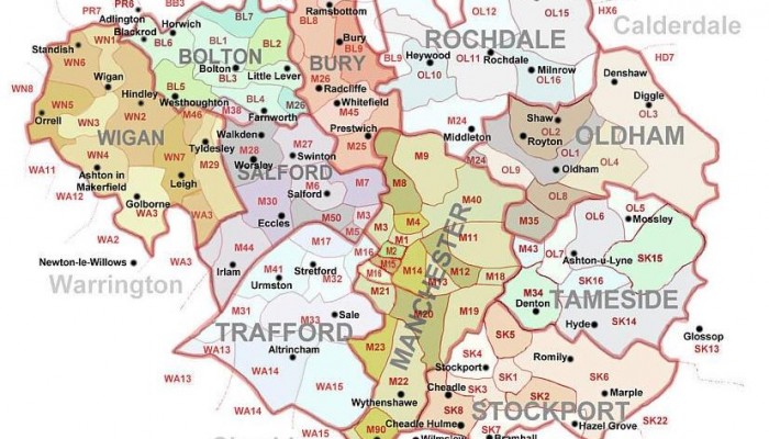
Manchester & Greater Manchester
An interactive version of this map can be found at www.manchester2002-uk.com/maps/postcodes-map.html.
The Ten Boroughs
Greater Manchester Metropolitan County was invented in 1974 as an administrative entity. It contains 10 boroughs, all of which have their own council.
Two of these boroughs are the cities of Manchester and Salford and their councils’ websites can be found here:
www.manchester.gov.uk;
www.salford.gov.uk/.
Six are towns: Wigan, Bolton, Bury, Rochdale and Oldham to the north, and Stockport to the south, and their councils’ websites are:
www.bolton.gov.uk/;
www.bury.gov.uk/;
www.oldham.gov.uk/;
www.rochdale.gov.uk/;
www.stockport.gov.uk/;
www.wigan.gov.uk/.
And two were created and are not named after geographical places: Tameside and Trafford. Their councils’ websites are:
www.tameside.gov.uk/;
www.trafford.gov.uk/.
Manchester

The original settlement lay where the River Medlock meets the River Irwell.
Historically, most of the city was a part of Lancashire, although areas south of the River Mersey were in Cheshire. As the result of an early-19th century factory building boom, Manchester was transformed from a township into a major mill town, borough and was granted city status in 1853.
Salford
Before the Industrial Revolution in the 18th and 19th centuries, Salford was a more important commercial and cultural centre than Manchester. The Salford “Hundreds” (districts) originally included most of modern Manchester, as far as Heaton Mersey in the south, Bolton and Bury to the north, Oldham and Rochdale to the east, and Warrington and Wigan to the west.
Salford was granted city status in 1926, having previously been a county borough.
The boundaries of the borough of Salford were set in line with the Local Government Act of 1972; Salford borough is separated from Manchester by the River Irwell and from Trafford by the Manchester Ship Canal. The administrative centre is Salford Civic Centre in Swinton.
Wigan
Wigan town stands on the River Douglas and is the largest settlement in Wigan borough. It was a mill town and a mining town, but also had traditions of porcelain and clock making.
Bolton
Bolton town stands close to the West Pennine Moors and is the largest settlement in Bolton borough. It was a mill town specialising in textiles manufacture.
Bury
Bury town stands on the River Irwell and is the largest settlement in Bury borough. It was a mill town specialising in textiles manufacture.
Rochdale
Rochdale town is the largest settlement in the Rochdale borough. It stands in the Pennine foothills on the River Roch. It was historically a market town which became a mill town in the Industrial Revolution.
Oldham
Oldham town is the largest settlement in Oldham borough. It lies in the Pennines on high ground between the River Irk and the River Medlock. It was a mill town.
Stockport
Stockport town is the largest settlement in Stockport borough. It lies on elevated ground where the River Goyt meets the River Tame and the two rivers flow together to form the River Mersey. In the 16th and 17th centuries Stockport was a centre of hemp cultivation and rope-making. In the 18th century it was a centre of silk manufacture. In the 19th century it was involved in the cotton industry and in hat-making.
Stockport town is dominated by the Stockport Viaduct which was built in 1840 to carry the mainline railways from Manchester to Birmingham and London over the River Mersey
Tameside
Tameside was named after the River Tame and the Tame Valley which cuts through the borough; its main town is Ashton-under-Lyne.
Trafford
Trafford was named after the De Trafford family who originally owned most of the land. It includes the towns of Altrincham, Partington, Sale, Stretford, and Urmston. The borough was formed on 1 April 1974 by the Local Government Act 1972. The River Mersey separates North and South Trafford; North Trafford used to be part of Lancashire and South Trafford used to be part of Cheshire. Trafford Town Hall is in Stretford.